10 July 2010

TEBAY!! (Day 2 part 2)

Borrowdale - Kirkby Stephen


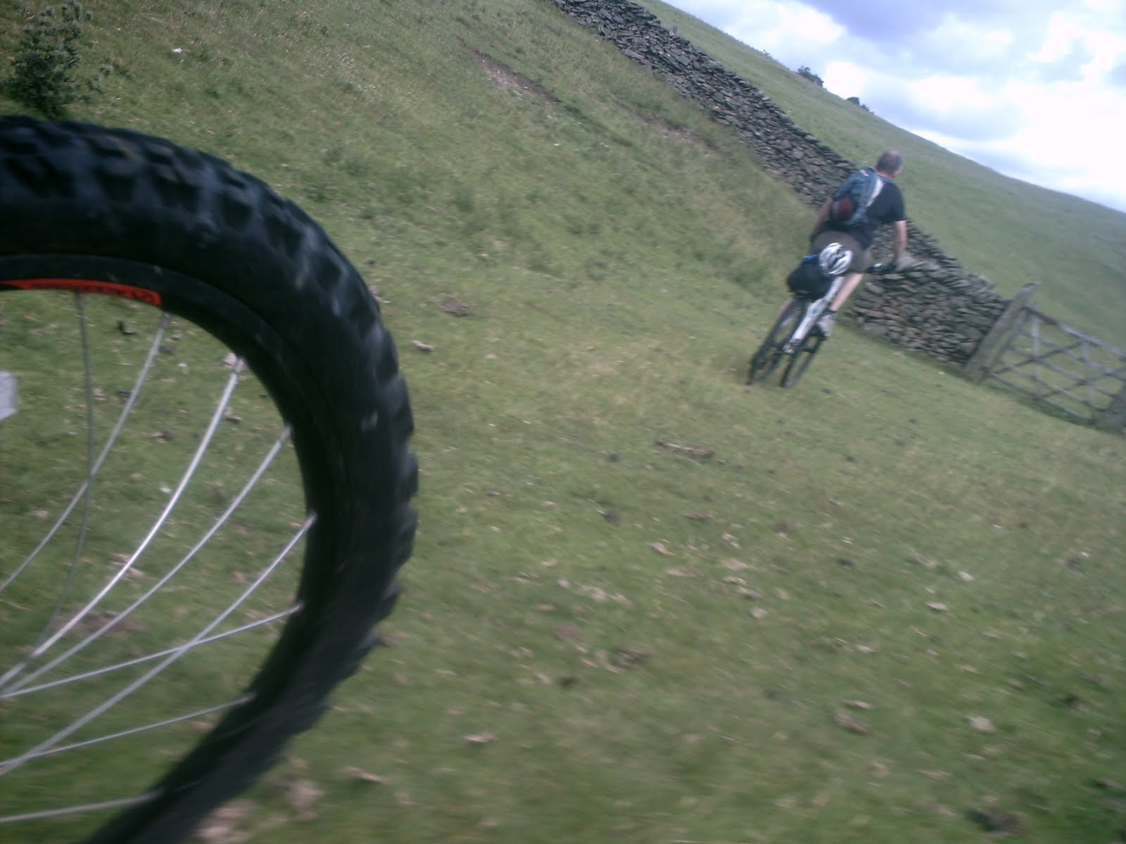
At the top of the hill we crossed the A6 in a break in the traffic and were able to look down the valley. The path was wide and well worn, but it was loose and bumpy. We dropped the saddles and kicked up some dust, sailing rather than riding over the loose scree, shifting balance to steer rather than relying on the tyres to grip. I hit a good bump and put some air between the wheels and the ground, wishing there was somebody with a camera to catch it. I certainly wasn't stopping to take one myself! Martin says he heard me whooping a couple of times as I left him behind. It might have been to tell the sheep to get out of my way, but equally, I might just have been enjoying myself.

When the terrain eventually levelled out, we crossed the river and stopped while Martin found a phone signal and returned some business calls. We cycled on beside the river, pulling on our windproofs and waterproofs as we encountered the valley's wind funnel effect and the first rain of the trip.

Eventually the trail became a track, which turned into a road through the woods, and finally ended in a junction, where we could see the motorway passing above us and an old railway viaduct beyond. We rode under them both and made our way round to a path marked on the map. It was a hidden gem on the journey. 
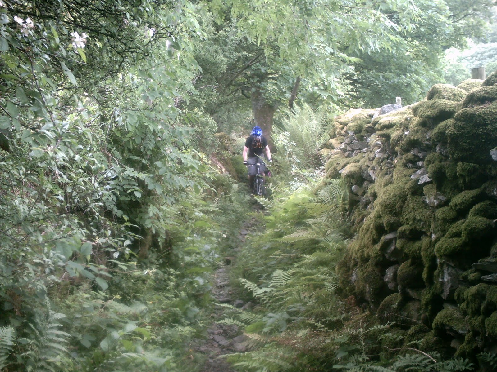
If this had been a sightseeing trip that fairy glen would have been a highlight, but it was a cycling trip and that glen was both impossible to ride and, because it was a footpath - not a bridleway - riding would have been illegal. So we dismounted and pushed, but it wasn't a chore this time.

the path followed the river Lune and beyond it, the motorway, right up to Tebay.

Tebay. A significant stopoff for both Martin and me.

When I was a kid growing up, we pulled that caravan from the boat at Stranraer down the motorways to Devon every year. Most years we stopped in Tebay to break the journey, so the very name 'Tebay' evokes some of my best childhood memories; holidays, car games, the whole family singing funny songs, driving through the night and most importantly, a peaceful oasis on long journeys.

For Martin, Tebay was also a stopoff on long journeys. As he worked on electrical installations up and down the country he'd stop in Tebay services and dream of riding coast to coast. Every time there was anyone else with him he'd bore them with details of how someday he'd ride his mountain bike from St. Bees to Robin Hood's Bay.

We probably stopped too long in Tebay Services, but we took on plenty of junk food, hot chocolate, coffee (Martin had to sit in the cafe where he'd dreamed of this journey so many times) I bought Pork Scratchings which I'd never tried before, and Kendal Mint cake as gifts for my family.

As we stood outside in the drizzling rain, a car pulled up with a couple of mountain bikes in the boot. They'd had a washout couple of days in Wales, and when they heard we were riding coast to coast they replied with a single word. "Respect." I laughed to myself. I don't really consider myself to be much of a mountain biker, and to get respect from guys who looked like hardened veterans felt good.

leaving Tebay, we didn't feel like doing too much thinking about our route. If we headed along the A685 we'd end up in Kirkby Stephen in a couple of hours, and that sounded good. We put our heads down and pumped along the road with cars bombing past at eighty miles an hour, missing us by inches. It was disheartening, because the road was so straight it felt as if we weren't making any progress. I took the lead for the first few miles, and then when I started to flag, Martin passed me and I tucked in behind him. Everything I dislike about road riding was embodied in those few miles. I tried to pass the time by matching Martin's gear changes, by trying to keep my front tyre an inch from his back, by singing songs to myself in time to turning the pedals. In the end I just zoned out and pumped.

We could see Ash Fell towering ahead of us from miles back, but there was no use worrying about it until we got there. When we reached it, it was a slog. I took the lead again and we plodded our way up. and up. the fact that it was boring just made it harder, but eventually we reached the summit.

up...down.

For once I had my phone switched to tell me what speed I was doing. My helmet peak was pulling my head up as I rode into the headwind, and When we crossed into the 20mph limit going into Kirkby Stephen it read 40mph, which is pretty fast on a mountain bike with big knobbly tyres. Thankfully there was no speed camera.

I braked hard, and when Martin caught up I still had a big grin on my face. We pedalled in a leisurely fashion along the main street. I asked Martin if he knew how far it was to the Youth Hostel, and he answered by pointing to it.

Recovering (Day 2 part 1)


Ambleside - Borrowdale

The best thing to cure the distaste for off-road riding that we'd accumulated after Monday's drudgery, was ten miles riding on the road along the A591. Oh the scenery wasn't boring, in fact it was rather beautiful, but trudging along a busy tarmac road on knobbly tyres while the traffic builds up behind you is really not my idea of fun. We even had to pull in at one point to let the queue past, the way I remember my dad had to do when we were holidaying in Devon with our overweight caravan and underpowered car. Ten miles of that and I was ready for off-road again.

When we got to the village of Staveley we held a conference. No lunch yesterday was a really bad idea, but 11:30am is surely too early for lunch. But who knows if we'll pass anywhere else? We passed the Staveley Chippy just as they were opening for the day and the bench outside helped sway us.

I ordered first, which was probably a bad idea.
"Curry Chip please"
The woman gave me a blank look.
Then I remembered, this is England. Never use two words when ten will do.
"Please may I have a portion of chips, with some curry sauce?"
That sorted it, and Martin ordered a chip. Sorry, a portion of chips. Strangely they didn't take American Express, so Martin paid from his wad of notes.

I'd be interested to hear from any girls reading. When a bloke sees you walking down the street and his head turns to follow your progress, how do you feel? do you take it as a compliment or do you think his ogling's rude? The reason I ask is that as we sat and ate our early lunch, I was ogling. Iwas ogling a carbon fibre singlespeed fixed gear with custom semi-dropped bars. beautiful. (oh, that's a bicycle by the way) but when I eventually got around to looking at the fellah in the saddle, I could see that he was ogling our bikes too. I nodded and he rode on. Next thing I knew he'd turned and come back.
"nice frame bag" he said (now there's a chat up line if you ever need one!)
and we chatted for a while. He actually worked at Wheelbase in the village, so after we'd finished eating we headed round that way for some advice.
With his help, we mapped out a route that was a good mix of B and C roads to Garnett Bridge, followed by bridleways as far as the motorway. Then at Tebay, we could decide how to get to Kirkby Stephen, where we were booked in for the night.

The route to Garnett Bridge was probably some of the most pleasant road cycling I've ever done. The long steep ascent to Gilpin Bank was probably hard work, but what I remember about it was how enjoyable it was to ride on the quiet country roads, with great views and interesting details all around. Then the ride down the other side to Garnett Bridge was a blast. We probably weren't going that fast, but it was a great fun ride.

We stopped briefly at Garnett Bridge to eat our chocolate croissants from the Youth Hostel, and began the off-road section of the day.


We began riding up a short steep bridleway to meet with the A6. Most of this section to Borrowdale followed the A6 quite closely, but apart from a mile or so, we were sticking to laneways and bridleways that ran parallel to the main road.

Being unfamiliar with English ways, I was surprised to find that many of the bridleways are just fields with a gate at either end, with little or no track marked out. Everything was well signposted though and it wasn't difficult to navigate. The biggest issue was that grass is one of the most physically draining surfaces for cycling. you seem to have to pedal twice as far to go the same distance on grass as you do on hard surfaces.

There are two clear routes from Borrowdale to the M6. The Breasthigh Road goes over the top of the mountains, while the other route follows the valley, coming out further south. The weather looked like it was going to close in within the next couple of hours, so that, coupled with the fact that the easiest place for a bicycle to cross the M6 looked to be further south, helped us decide to ride along the valley.

09 July 2010

Ambleside YH

Ambleside Youth Hostel was busy when we arrived. The reception staff were friendly and helpful, told us where we could lock up our bikes and which room we’d be sleeping in.

On top of the cost of the room we had to pay £4 each for a cooked breakfast, £3 for a padlock and £2 for Martin’s towel. Actually when you add it all up, a Youth Hostel's not much cheaper than in a bed and breakfast, especially when you consider the fact that there were 9 beds in our room (all occupied at some point during the night) and there were only a couple of toilets and showers to accommodate the whole floor.

I was zonked, and if the aliens had invaded that night I’m not sure I’d have noticed. We locked up the bikes in the shed round the back, barely glancing at the sunset over the lake, and I got bed sheets because mine had gone missing. I then had a quick shower, took out my phone battery and charged it up (an external charger costs about £2 and is less likely to get nicked than the phone) and up the ladder into bed, while Martin got a padlock for the locker and chatted to a man from China who was youth hostelling around the UK.

Apparently we’d both drunk too much water on Day one, because both of us were up during the night. Everybody is so keen to stress that you shouldn’t get dehydrated, but it’s just as easy to go the other way (less dangerous though!) we were also thoroughly sick of cranberries, nuts and jelly babies, and Martin decided he was never going to touch High5 powdered carbohydrate mix again.

Next morning I was feeling much better. We had a choice of routes for today, and although neither of us wanted to appear ‘soft’ we both dropped enough hints to each other that the easier route would be better, that nobody lost face by being the first to back down. Sometimes it takes diplomacy to be a bloke on a man’s adventure.

They’ve got a clever system going in the youth hostel at Ambleside. We’d paid for our cooked breakfast the night before when we arrived, low on energy. After a good night’s sleep, however, I didn’t want a cooked breakfast of any sort, and Martin only wanted eggs and bacon. I made up for it by eating three bowls of cereal and spilling a fourth all over the floor. Plenty of fruit juice and toast, and we nicked some chocolate croissants for later.

Packed up and collected the bikes from the shed… and mucked around watching a kayaking lesson on the lake for an hour. We fixed my punctured tube, Martin showed me a better way to do it, filled our water reservoirs, and eventually swung our legs over the saddles at about half past ten, to continue our journey East.

Struggling (Day 1 part 2)


Wasdale Head - Ambleside

We’d been stuffing ourselves all morning on cranberries, raisins, nuts, jelly babies and bananas, so we weren’t hungry and decided to keep going from Wasdale Head, without wasting time and money on lunch. (one).

I checked my kit was securely attached and my tyres were soft enough to give good grip on the soft ground (two).

A biker on a Harley Davidson bike told us that of the two paths marked along Lingmall valley, the upper path along Great Gable would definitely be the easier, because the lower one had a ridiculously steep climb up to Sty Head at the end. (three) and so we set off that way.

It’s not easy to get away from Wasdale Head pub. It’s surrounded by sheepfolds with dry stone walls, and it’s difficult to see where the path is, or if you’re on the right one. We saw more than one group head off in one direction only to discover they were going completely the wrong way and turn back. We cycled along the road for a few metres before noticing the signpost behind us for the path heading the way we wanted to go. Once we’d negotiated the sheepfolds, we headed along the base of Great Gable. We were able to ride up to the gate, part of the way along the path, but after that it was pushing all the way as the loose pebbles coupled with the steep slope was some of the most energy sapping riding I’ve ever attempted. Yes, there were places we could have ridden, but getting on and off the bikes would have used more energy, and even when we rode, we moved no more quickly than when we walked. More than once I looked down at the track along the base of the valley, wishing we’d never followed the Bikers’ advice. (three)

Somewhere along that long slog, I picked up a snakebite puncture. The path wasn’t the mud I’d expected and was familiar with, so having soft tyres was totally the wrong approach (two). We had to stop and swap out the tube of my rear tyre before continuing. I was exhausted, my wrist was giving me trouble, and everything was taking longer than it should, so I was grateful when Martin shooed me away and did most of the work.

We hadn’t ridden much together and a few patterns were appearing. On the bikes, riding normal endurance cycling, were are pretty well matched. I ride slightly faster than Martin, but there’s not a massive difference. When we’re pushing and carrying, Martin’s way ahead of me. It’s not just that his bike’s lighter and that my frame bag hampers me carrying, he’s just much better at pushing. On fast downhills, I ride full throttle, brakes off, while he’s more cautious. But on very technical riding, he cycles where I wouldn’t dare. We have different strengths and weaknesses, but nothing that makes us incompatible as cycling buddies. Just as well, because we still had a long way to push before Sty Head, and a long long way to ride before Robin Hood’s bay.

Tyre fixed, and pumped up hard, we pushed on, trudging up towards the top, stopping to watch hikers struggle over boulders and cliffs, before shouldering the bikes and tackling them ourselves. This was the first of many times we heard people say “you’re spoiling a good walk, carrying those” and we agreed wholeheartedly, but we always had the hope that once we got over the highest point, it’d be downhill all the way and they’d look jealously at our backs as they trudged down in our wake.

It was a futile hope. From Sty Head down to Sprinkling tarn the Lake District’s volunteers have created paths from boulders that make life easier for walkers, protect the hills from erosion, and make riding impossible. From us hauling the bikes uphill, we were now holding them back as they tried to pull us off the path and down to the rocky chasm below. The descent was slow, draining, and disheartening as we watched more hikers pass us, spewing their jolly banter and meandering on their merry way. Even the short section we rode down from Sprinkling Tarn was unrelenting hard work, and watching someone set up camp for the night around Angle Tarn was probably the low point of the whole trip, because we knew we still had fifteen kilometres to go before the Youth Hostel at Ambleside.

We had a short break after Angle Tarn, and got chatting to a man who was actually quite excited. I didn’t catch the whole story, but I believe he worked with disabled people, and of the half dozen strangers he’d had conversations with that day in the hills, one of them provided resources to help disabled people work. They’d exchanged contact details, and it was very likely that they’d start doing business together. I do like coincidences like that, but by that stage I was mostly thinking “food!” “bed!” We got another frustratingly short cycle from Angle Tarn before manhandling our wheeled hindrances alongside Rossett Gill, all the while eyeing the smooth track of the Cumbria Way that we hoped would be our route out.

What would, at the beginning of the day, seemed like ‘proper off road’ now felt like the snooker-table smooth track of Silverstone. The mile and a half to the Old Dungeon Ghyll hotel flew by, and we stopped there for some desperately needed food (one). The afternoon would probably have been much easier if we’d eaten a decent lunch. When the food we ordered eventually did come, I picked at it, ate a few chips, just enough to lift my morale, and started badgering Martin to get going. I was exhausted like I’ve only been a few times in my life, and I know there’s only one cure. Sleep. Martin forced his into him, and as soon as possible, I persuaded him to pedalled on. I don’t remember much about the next ten miles. I think we took the old bridleway to Chapel Stile; I think there was traffic in Clappersgate; I think I went the wrong way up a one way street in Ambleside because it was shorter; but one thing I do know: After 13 gruelling hours travelling, bitterly regretting three bad decisions made at Wasdale Head, we made it to Ambleside Youth Hostel and bed.

Departing (Day 1 part 1)

Saint Bees to Wasdale Head.


We woke up to sunshine and birds singing on Monday morning.

At breakfast we met an Australian woman who had shipped her bike to Robin Hood’s bay and was about to set off and walk across to pick it up. Carole told us that there’s been a steady stream of walkers this year, probably due to Julia Bradbury’s TV programme.

We got washed, pulled on our cycling shorts and saddled up, leaving the guest house at 9am.

Our first section was on the road. We expected day one to be a long and difficult one, so we wanted to get to Ennerdale water as quickly as possible. Things didn’t look good for our chances of navigating across the country when I sailed on past the first turn off, but with the GPS and Martin calling me back, we lost less than a minute. Our first experience of off-road was pleasant enough, the track from the road to the edge of the water turned and followed the shore. We met a German couple on old town bikes coming towards us, and they warned us that the route was impassable up ahead. I have to admit I laughed quietly to myself. Impassible is nothing. We were here to make the impassable passable. We turned the corner and stopped. There was a stream, and on the other side, nothing. Just a mass of thick fern groundcover.

I crossed the stream first and dismounted. I reached down pushed aside an armful of fronds and saw that the ground beneath was worn. I pushed back a bit further, and began to see a path. The entire trail had been overgrown with ferns, making it totally invisible.

On the bikes, now we knew what we were looking for, we were able to follow the dimple that had once been a path right round the north shore of Ennerdale. Where the ground was flat and the path worn smooth, this wasn't a problem, but on a couple of occasions, the ferns concealed treacherous obstacles, and Martin picked up the first injury of the trip. Catching an unexpected rock, his foot slipped and he knocked his shin with the pedal. Thankfully not too serious.

After about 3 miles of invisible path, we cut up onto another trail that was wide enough and smooth enough to drive a car along. We passed a few Duke of Edinburgh groups and day walkers, and caught glimpses through the trees of the peaceful lake beside us and the foreboding mountains ahead. I know using words like 'foreboding' in a blog usually sounds like you're trying too hard to write classy literature, but I did think long and hard before I used it. I rarely think much beyond the next turn of the pedals, but as we left the trees behind and the lake turned into a stream, those black mountains beginning to block out the morning sun made me consider what was ahead, and it wasn't pleasant. It also didn't help that Martin kept pointing at them every two minutes.

Every account I've read of a mountain bike attempt across England specifically mentions that they had to push and carry up Black Sail pass, and as we sat outside Black Sail Hut looking up at that pass I knew mine would say the same, and anyone reading that line of text would never fully understand the effort involved until they tried it themselves.

We had to push the bikes up Black Sail Pass.

Once we got to the top of the pass, we were able to enjoy a long, reasonably technical downhill to Wasdale head, where we stopped for another break.

It had been hard, work, but as we wandered round the shop and sat in the sun, and I mulled over the question of how the English can, on one hand make jokes about how daft the Irish are, but on the other post a 'No Picnics' sign above a picnic table, we were elated that our journey had begun in earnest, and we'd conquered the first real challenge of our route. Yep, the First Real Challenge. We were in our rhythm now, and the rest would be easy. How little I knew.

08 July 2010

Arriving (Day 0)

On Sunday, we left the family behind and threw the bikes into Martin’s van. His mate Jez joined us for the 4 hour journey to St. Bees. Martin was buzzing, he’d driven most of this journey hundreds of times with work, dreaming of riding coast to coast. He didn’t say much, but there was an air of excitement around him that almost hummed as he urged the van to go faster towards our starting point. I was quiet too, wondering what I’d let myself in for. After the Mournes I had no confidence that I’d be able to ride across even moderately challenging terrain, Despite the ordnance survey maps and satellite navigation, on my phone, the compasses, the maps, I was sure we’d get lost. Would my bike hold up, would the new tighter chain stop the ride on the first day? Would I fall off at the simplest hurdles like in Woodburn? On one hand, I was full of doubt. On the other, I was desperate to get started, to put all the problems I’d encountered in my training behind me, and get stuck into the adventure I’d been preparing myself to undertake.

Jez somehow managed to keep a conversation going single handed for the whole four hours. He covered yoga, conspiracy theories, freemen of the land, corporate greed, water filtering techniques, hydroelectric cars, drug use, the UK court system and wireless electricity. Oh yes, and he talked about mini cooper cars, property ownership and human anatomy too.

When we got to stonehouse farm Carole showed us the excellent annex/bungalow where we’d be staying. A bedroom, a shower room, and a living/kitchen/bedroom. We offloaded the bikes, changed from our jeans and shirts into the cycling shorts and tees that we’d be wearing for the next week, and Jez turned around and drove the four hours back to Martin’s house. I can only guess what topics the conversation covered on that journey.

While Martin prepared a pasta carbonara for us to eat, I borrowed his bike and rode down to the water’s edge. Tradition dictates that anyone riding coast to coast should dip their back wheel into the water in St. Bee. I’ve done it, and Martin’s bike has done it. I also selected a more permanent proof of the journey, a pebble from the beach which I intended to carry across the country with me to the other side.

Back at the B&B, my headache, which had been developing most of the afternoon, got quickly worse, and I was only able to force half of the pasta down my neck before stumbling to the bedroom and collapsing into a fitful sleep.

07 July 2010

navigation

For a trip like this, navigation is everything, and I've already proved that my sense of direction's far from perfect.
We both had compasses, Martin carried maps covering the Lake District and the North York Moors.

I had my phone.


I always knew my Nokia 5800 did a lot of stuff, but on this trip it blew me away.

I've got Alex Fischer's AFTrack software on my phone.

I loaded Ordnance Survey maps from Bing and calibrated them using satsig.net. It was time consuming, but very worthwhile.

I cable tied a cheap silicon holder to my handlebars so I could see the screen when I was riding, and,

HEY PRESTO!

I had satellite navigation which told us exactly where we were and what direction we were travelling. It even told me what speed I was doing while playing a selection of MP3s. The holder gave good shock resistance, it never fell off, and I was able to take the phone out easily on the rough off-road sections or when I wanted to make a phone call (yes, you can even use the Nokia 5800 XPressMusic to make phone calls!). A fully charged battery lasted all day, but I started every day with two charged up. Just in case.

I would never rely on just a gps for navigation; too many things can go wrong, but it turned out to be an amazing setup and saved us a lot of faffing about on windy mountain tops.

02 July 2010

packing

After a couple of days being tourists, Martin and I sat down to prepare what to take for the trip. Not wanting to double up on too many things, we laid out everything on their garden table and packed away things we wouldn't need.

I took:
frame bag, right pocket:
spare inner tube, pump, puncture repair kit, 4 links of chain, allen keys.
frame bag, left pocket:
sun cream (factor 50), camera, insect repellant.
drybag:
first aid kit, socks, boxer shorts, long sleeved cycle shirt, jogging trousers, t-shirt for sleeping.
backpack, main bag:
3-litre water reservoir, spare food (dried fruit, nuts, chocolate), waterproof jacket, waterproof trousers, travel towel, extra padding for cycle shorts, emergency bag (bivi, water purifying tabs, lighter, phone charger/light).
backpack, front pocket:
toothbrush & soap, keys, wallet, spare phone.

We both also had bar bags to keep food within easy reach.

In the end I'm not exactly sure what Martin took. He had more clothes than me and didn't take a towel, but overall I think we were carrying roughly the same weight. Martin decided at the last minute that he didn't need his hard-back book BS7671 Requirements for Electrical Installations and I was inclined to agree.

01 July 2010

tension mounting

Northern Ireland school holidays are from the start of July to the end of August, so as soon as school finished, we headed for the Larne Ferry.

A couple of days with Martin, Tiny and Co. we did holiday things and on the surface it probably looked like we were relaxing. Inside, Martin and I were raring to saddle up and start riding.

We went to Thomas Land, and went out for a family cycle, went to the beach and played in the garden. Time with the family is great, but I'm sorry to say that my mind was elsewhere.

23 June 2010

bumbling about

Once past that first hurdle my spirits lifted, and I was able to ride. Some of the descents were a little hairy – I was on my own, so I sometimes walked rather than risk injuring myself, but I was in a good mood. Following the path down from the saddle between Meelmore & Meelbeg I knew I wouldn’t have time to do more than follow the base of Slieve Meelmore, out onto the Trassey Track and back to my tent, either rejoining the section of the Ulster Way that passes the campsite, or out through the forest onto the road.

I was in my element.

There were a couple of places where the path wasn’t totally clear, but that was OK, I just kept going till I picked it up again.
There were one or two paths heading off to my left, but that was OK, I just had to keep the mountain on my left.

The sun began to set, but that was OK, I was enjoying the technical riding,

I knew where I was and I knew where I was going… until I rounded a corner and found myself looking down a valley at a large body of water that definitely wasn’t on the map. It was a very large body of water, and the people who made the map really shouldn’t have left it off. Actually, it was so big that somebody had built a dam across it and it could almost be mistaken for a big reservoir, and it definitely wasn’t on the map… unless I had strayed a little bit off the path, or missed a turn…

Map out, I realised I was looking down at Ben Crom Reservoir, and while I’d been concentrating on looking down at the technical trail I’d forgotten to look up and see the that I was actually going round the base of Slieve Bearnagh instead of Meelmore – and that it was actually getting dark.

I had the choice of working my way round Bearnagh (scary) to Hares gap and down, or backtrack and take the longer but less treacherous path between Bearnagh and Meelmore. I opted for the cautious route. Riding some, but mostly pushing. Trails that were fun at dusk on the way down became impossible in the dark on the way back up and I eventually made it to Trassey Track at about 1230.

Almost as soon as I got on the track, I looked up and watched the mist descend. The easily identifiable peaks very quickly became invisible through the pale blanket. Half an hour later and I wouldn’t have been able to find the path. I wasn’t too concerned; I had my emergency bivi, a couple of spare lights, and enough food and water to last me well into Friday. I didn’t see any reason to worry, but I was annoyed that I’d wandered so far off my planned route and that my journey home was so frustratingly slow.

My progress was hampered further by the fact that my chain had at some point bounced off the chain ring and into the gap between the ring and the frame. It was trapped there, and I couldn’t prise it out, so when I got to the path I split the chain with my chain tool and forced it through. I reconnected the chain, but I could see that some of the links were twisted. Even when the path smoothed out, I wasn’t going to be able to ride.

It was slow going, but eventually I made it to the Ulster Way marker. I started to push along the wall, but there was a group of about ten tents along the path – with litter, abandoned meals and empty tent bags scattered on the ground all around. I was annoyed with myself, I wasn’t pleased that they were camped right on the path, and I was righteously indignant that they’d made such a mess. At half past one that morning, a large angry animal bumbled through their camp… pushing a damaged bicycle. I practised my evil chuckle when they nervously called out “Who’s there? Do you hear that? What’s that noise?” I’m bad.
At nearly two in the morning I locked the broken bike to the fence out of habit, crawled into my tent, pulled the sleeping bag over me and slept till morning - woken only once by a sheep eating the tent.
In the morning, with the bike unrideable, I'd no choice but to pack up and head home. Would I have tried another ride after the marathon of the night before? I don't know, but I'm glad that chain got mangled on my practice ride rather than on the first day of the coast to coast.

worth the effort

I’ve heard mixed reports about Meelmore Lodge. Some say it’s full of groups playing loud music late into the night, others say if you’re not husband, wife and 2.4 kids they’ll turn you away because they’re a ‘family site’. Some say it’s spotless, others say it’s filthy. Needless to say I had no idea what to expect. All I needed was a sheltered stretch of grass to pitch my tent, and somewhere to take a shower before I went home. What I got was as clean and comfortable a site as I’ve ever camped. Well kept grass, two toilet blocks, showers (which cost £1 a go) – all clean; friendly helpful staff, who stayed on site all night in case of trouble. Basic, but pleasant and well maintained. And I don’t think a fiver was too dear – especially when it’s so close to the mountains.

There were a couple of DofE groups, and a few hikers, but it was Thursday night, so it wasn’t busy; and the location is amazing, with an awe inspiring view of the mountains.

I fired up the trangia, and while the water boiled I pitched my tent.

I boiled up some couscous with curry powder, threw in a few raisins from my trail mix, and munched it down it straight from the saucepan while I pondered various routes on the map. Idyllic.

I planned to ride for two hours on Thursday night, and then four hours on Friday morning before heading home.

For Thursday, I thought I’d head along the Ulster way, to the path that goes up between Slieve Meelmore and Slieve Meelbeg, up into the Mournes, and then make a decision based on how long that took me.

The sun sets at about ten thirty at the end of June, but it’s light enough until nearly half eleven, so I got all cleaned up and on the bike by eight, and I was happy enough with that. I set off at my usual pace when I think there’s people watching – fast enough to get me out of breath within a couple of hundred yards – so by the time I reached the stile I was glad for the excuse to get off and push for a while. I headed off to the right – and realised riding was hard going. Sure there’s a path, but it’s about six inches wide, and it’s deep enough that the pedals would keep catching. I just couldn’t get any sort of rhythm going. I pushed a bit, tried to ride, got off, and pushed a bit more. In the end I pushed most of the way round the base of Slieve Meelmore, and when I looked up at the saddle between the two mountains I realised I’d just pushed the easy bit.

Undaunted, I pushed on.

All those authors who use that phrase in their books, they don’t usually mean it quite as literally as I do here.

There were one or two places where I thought to myself “I could probably ride this section, but I need to conserve my energy for that vertical bit up ahead”

“If I clear the lip of the saddle by 9pm… just after 9pm… a quarter past nine… half nine… I’ll still be able to get back to camp before it gets dark.”

I finally got over the wall just after half nine, and it was beautiful. The orange sun low in the sky behind me highlighted every white granite boulder and black peaty crevice against the green carpet that stretched over a mile across the valley floor to Cove, Doan and Slievemalagan. Everything was utterly still, not a soul in sight and in the shelter of the wall there wasn’t a breeze.

I love the Mournes.

Yes OK, I know that’s not exactly what I said in my last post, but occasionally, just occasionally I reserve the right to change my mind about these things.